Interim govt in troubled Nepal shows hostility towards India, releases new banknote with revised map of the country including Indian territories
The Nepal Rastra Bank (NRB) on Thursday (27th November) issued new Rs 100 currency notes featuring a revised map of Nepal, misrepresenting three Indian territories of Kalapani, Lipulekh and Limpiyadhura as part of Nepal. The new currency notes bear the signature of the previous Governor, Maha Prasad Adhikari. The date of issuance of the bank note is 2081 BS, which denotes the last year, 2024. An image of Mt Everest is displayed on the left side of he new Rs 100 currency note, and a watermark of Nepal’s national flower, Rhododendron, is featured on the right. The centre of the note shows a faint green coloured map of Nepal with an image of the Ashoka Pillar printed next to it. The words “Lumbini, the birthplace of Lord Buddha” are printed at the centre of the bottom of the note. Notably, the map’s design has not been changed, it is in circulation for several years. But the map on the note has been changed, as per the Nepal govt’s decision to revise the country’s map to include three Indian territories. A picture of a one horned rhino with a cub is printed on the back of the note, which has a security thread running through it and an embossed black dot, to help visually impaired people recognise it. According to an NRB spokesperson, the map on the new Rs 100 note was already there, and it has been revised as per the decision of the government. He added that among the banknotes of various denominations, such as Rs 10, Rs 50, Rs 500, and Rs 1,000, only the Rs 100 currency note bears Nepal’s map. Nepal revised its map under the previous Oli-led government Notably, in June 2020, the previous K P Sharma Oli government had revised the country’s map through a Parliament endorsement to include three Indian territories of Kalapani, Lipulekh and Limpiyadhura in it. Reacting sharply to Nepal’s move, the Indian Ministry of External Affairs rejected the updated map of Nepal, saying that the artificial enlargement of the map is not based on historical facts, hence it is not tenable. Nepal’s action came after India inaugurated a link road in May 2020, linking the Kailash Mansarovar route in Pithoragarh in Uttarakhand to Lipulekh. The Nepali foreign ministry issued a statement claiming that the link road passed through Nepal’s territory. Nepal, in the past, has called for diplomatic discussions with India to resolve what it perceives as a territorial dispute between the two countries. India has, however, denied any territorial disputes with the country, maintaining that Nepal’s claim on the territories in question lacks a historical and factual basis. Nepal raised the issue again in August this year after India announced the revival of commerce through Lipulekh with China. It reacted strongly to the announcement and regurgitated its claim on the territory. Nepal picking up fights with a valuable neighbour The former Hindu Rashtra recently went through a phase of political instability, which resulted in the ouster of the Oli-led government. The country is currently being governed by an unelected government. Considering these circumstances, Nepal’s decision to raise an imaginary territorial dispute with India appears like a poor diplomatic decision. At a time when the country, which is recovering from the impact of large-scale protests against corruption, should be focusing on its own political stability, it is choosing to manufacture conflict with a generous neighbour like India, which has stood by the country through thick and thin. Given the country’s unique geopolitical position and its common security concerns with India, Nepal should prioritise domestic and bilateral peace. However, overlooking the longstanding traditional, cultural and civilisational ties with India, the country has adopted an aggressive diplomacy towards India under pressure from the United States. What is the Lipulekh Dispute Lipulekh Pass is situated in a tri-junction region claimed by Nepal and India. Nepal incorporates Lipulekh, along with nearby Kalapani and Limpiyadhura territories, into its official maps and constitution, claiming them in accordance with the Treaty of Sugauli’s designation of the Kali River as the frontier. But Nepal’s claim is disputed by India, which claims that the river originates downstream and hence this land belongs to Uttarakhand. India contends that Nepal’s claims lack a historical and factual basis, seeking dialogue while maintaining control over the land. The Lipulekh route, which connects India and China along their contentious Himalayan border, is strategically important. Lipulekh has also been at the centre of a historic bilateral commercial arrangement between India and China, which was renewed recently. The Treaty of Sugauli was signed on December 2, 1815, and ratified on March 4, 1816, between the Kingdom of Nepal and the British East India Company, ending the Anglo-Nepalese War. Under the treaty, Nepal ceded parts of its territory, including areas west of the Kali

The Nepal Rastra Bank (NRB) on Thursday (27th November) issued new Rs 100 currency notes featuring a revised map of Nepal, misrepresenting three Indian territories of Kalapani, Lipulekh and Limpiyadhura as part of Nepal. The new currency notes bear the signature of the previous Governor, Maha Prasad Adhikari. The date of issuance of the bank note is 2081 BS, which denotes the last year, 2024.
An image of Mt Everest is displayed on the left side of he new Rs 100 currency note, and a watermark of Nepal’s national flower, Rhododendron, is featured on the right. The centre of the note shows a faint green coloured map of Nepal with an image of the Ashoka Pillar printed next to it. The words “Lumbini, the birthplace of Lord Buddha” are printed at the centre of the bottom of the note.
Notably, the map’s design has not been changed, it is in circulation for several years. But the map on the note has been changed, as per the Nepal govt’s decision to revise the country’s map to include three Indian territories.

A picture of a one horned rhino with a cub is printed on the back of the note, which has a security thread running through it and an embossed black dot, to help visually impaired people recognise it.

According to an NRB spokesperson, the map on the new Rs 100 note was already there, and it has been revised as per the decision of the government. He added that among the banknotes of various denominations, such as Rs 10, Rs 50, Rs 500, and Rs 1,000, only the Rs 100 currency note bears Nepal’s map.
Nepal revised its map under the previous Oli-led government
Notably, in June 2020, the previous K P Sharma Oli government had revised the country’s map through a Parliament endorsement to include three Indian territories of Kalapani, Lipulekh and Limpiyadhura in it. Reacting sharply to Nepal’s move, the Indian Ministry of External Affairs rejected the updated map of Nepal, saying that the artificial enlargement of the map is not based on historical facts, hence it is not tenable.
Nepal’s action came after India inaugurated a link road in May 2020, linking the Kailash Mansarovar route in Pithoragarh in Uttarakhand to Lipulekh. The Nepali foreign ministry issued a statement claiming that the link road passed through Nepal’s territory. Nepal, in the past, has called for diplomatic discussions with India to resolve what it perceives as a territorial dispute between the two countries. India has, however, denied any territorial disputes with the country, maintaining that Nepal’s claim on the territories in question lacks a historical and factual basis. Nepal raised the issue again in August this year after India announced the revival of commerce through Lipulekh with China. It reacted strongly to the announcement and regurgitated its claim on the territory.
Nepal picking up fights with a valuable neighbour
The former Hindu Rashtra recently went through a phase of political instability, which resulted in the ouster of the Oli-led government. The country is currently being governed by an unelected government. Considering these circumstances, Nepal’s decision to raise an imaginary territorial dispute with India appears like a poor diplomatic decision. At a time when the country, which is recovering from the impact of large-scale protests against corruption, should be focusing on its own political stability, it is choosing to manufacture conflict with a generous neighbour like India, which has stood by the country through thick and thin.
Given the country’s unique geopolitical position and its common security concerns with India, Nepal should prioritise domestic and bilateral peace. However, overlooking the longstanding traditional, cultural and civilisational ties with India, the country has adopted an aggressive diplomacy towards India under pressure from the United States.
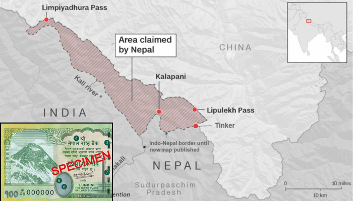
What is the Lipulekh Dispute
Lipulekh Pass is situated in a tri-junction region claimed by Nepal and India. Nepal incorporates Lipulekh, along with nearby Kalapani and Limpiyadhura territories, into its official maps and constitution, claiming them in accordance with the Treaty of Sugauli’s designation of the Kali River as the frontier. But Nepal’s claim is disputed by India, which claims that the river originates downstream and hence this land belongs to Uttarakhand. India contends that Nepal’s claims lack a historical and factual basis, seeking dialogue while maintaining control over the land. The Lipulekh route, which connects India and China along their contentious Himalayan border, is strategically important. Lipulekh has also been at the centre of a historic bilateral commercial arrangement between India and China, which was renewed recently.
The Treaty of Sugauli was signed on December 2, 1815, and ratified on March 4, 1816, between the Kingdom of Nepal and the British East India Company, ending the Anglo-Nepalese War. Under the treaty, Nepal ceded parts of its territory, including areas west of the Kali River, which includes the territories disputed by Nepal, up to the Sutlej River and the Tarai lowlands. Nepal is now asserting its claim on the territories of Kalapani, Lipulekh and Limpiyadhura, which lie west to the Kali River, based on its interpretation of the treaty.